
- Introduce
- Jyeokbyeokgang Noeul-gil
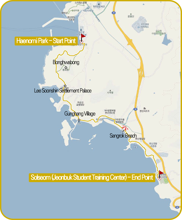
- Haeneonyi Solseom-gil
- Mohang mudflat path
- Ssanggyejae Nine Curves Road
One cannot talk about Buan-gun without talking about the sea.
In Unified Silla Era, it was called Buryeong-hyeon, and was part of Gobu-gun. In 1414, the 14th year of King Taejong from the Joseon era, it became Buan-hyeon after integrating Buryeong-hyeon and Boan-hyeon. After that, it became Buan-gun since King Gojong era.
When you ask a person who traveled the West coast which is the most breathtaking scenery, they will all answer that it’s Buan-gun.
As such, one cannot talk about Buan-gun without talking about the sea. Unlike other sceneries in the west coast, Buan-gun has various sceneries by erosion. The breathtaking views such as the Jeokbyeok river and Chaeseok river blend well with the sunset in the western coast, and grants you with a magnificent sunset view. Most of the coast is selected as a the Byeonsanbando National Park.
One cannot talk about Buan without mentioning the tasty food.
When you ask a person who traveled the West coast which is the most breathtaking scenery, they will all answer that it’s Buan-gun.
As such, one cannot talk about Buan-gun without talking about the sea. Unlike other sceneries in the west coast, Buan-gun has various sceneries by erosion.
The breathtaking views such as the Jeokbyeok river and Chaeseok river blend well with the sunset in the western coast,
and grants you with a magnificent sunset view. Most of the coast is selected as a the Byeonsanbando National Park.
The fish just caught from the west sea, a treasure trove of nutrients, will stimulate your appetite.
The porridge made with various types of clams,
and fresh sliced raw fish, and the salted seafood from Gomso Harbor will entice gourmet travelers.
Buan-gun part of the Jeonbuk Cheolligil is a course where you can enjoy the magnificent
view of the Byeonsanbandon national park along the coasts of Buan-gun.
The course consists of trails selected from the former ‘Buan Masil-gil’,
so you can walk each trail and feel the charm of the Western coast.
Let’s set off for the priceless
course now.
The Jeokbyeok river sunset road is a road known for the beautiful sunset, and you can see the Jeokbyeok river and Chaeseok river from here. The Haeneonyi Solseom-gil also proudly presents its beautiful sunset scenery. When the sun sets behind the pine trees of a small island, Sol-seom, you will be allured into the scenery. The Mohang Mudland Experiencing Path where you can walk on the beach surrounded by the beauty of Mohang, and Ssanggyejae Nine Curve road where you can see the Wangpo Village(filming site of ‘Urban Fisherman’) after passing through the tunnel made by the green bamboos, are also priceless trails.
The Jeonbuk Cheolligil Buan-gun Course will let you feel the life inside the taste and the beauty of the west coast. There can be a person who has never walked on this trail, but none has walked only once. Let’s set off for the priceless course now.

Jyeokbyeokgang Noeul-gil(Sunset path) (Buan Masil-gil Course 3)
The Beauty of the Geopark along the beach


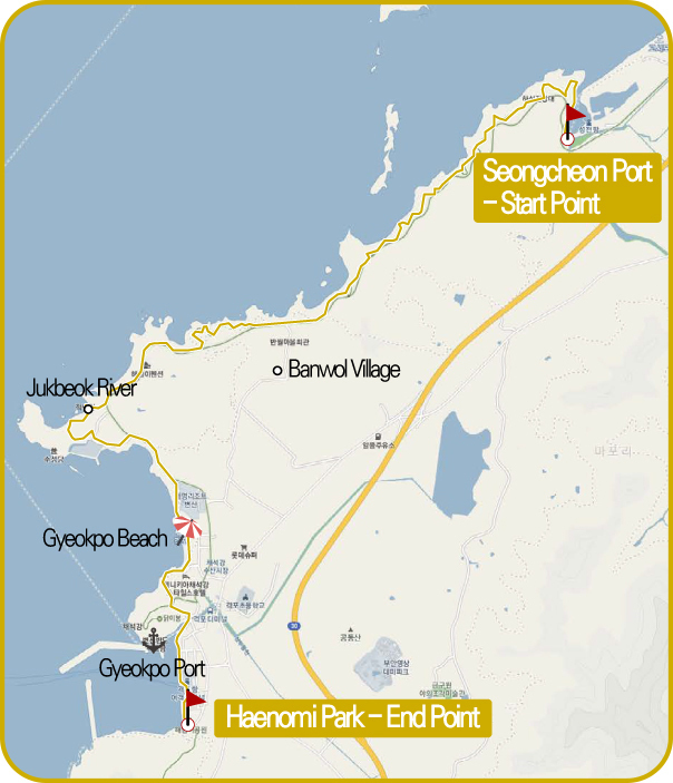

Quiet scenery at Seongcheon Port, the starting point
It is a beautiful road about 10km descending south from Seongcheon Port south of Gosapo along the west side of Byeonsan Peninsula. The journey begins with walking along the foothills at the end of Seongcheon Port, which is quieter and more peaceful than any port on the west coast.
The coast guard posts, which are no longer used, are preserved in the roads that appear soon after. In the wire netting along the cliff, the wishes of those who walked the path first hang on every wooden plaque. The patrol route winds along the coast for about 3 km until you reach a rest area near the road.
Keeping the sea nearby and not walking only the white sand beach is a characteristic and great advantage of the Jukbeok River Noeul-gil. You can't get bored for a moment: pine forest trails, bamboo forest trails, wooden bridges with swinging bridges, and views of the open sea.
Beautiful Island Haseom is a small island where nature allows you to go.
In addition, 'Haseom', which keeps its eyes while walking, can walk into the sea at low tide for about three days around the 1st and 15th day of the lunar calendar. If you keep walking, it is 'Banwol Village' where Buan Masil-gil Tourist Information Center is located.
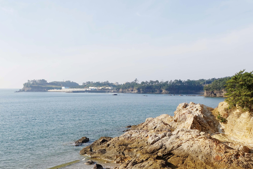
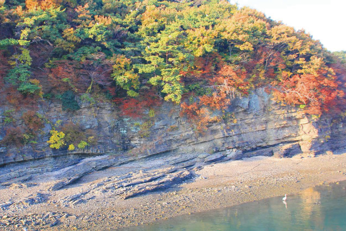
After taking a short breath here, you pass the 'Small Dangsa-gu' on the beach. At about 6km, we finally meet the protagonist of Jukbeok River Noeul-gil'. Nationally designated scenic spot 13, Jeollabuk-do West Coast National Geopark Jukbeok River and Chaeseuk river.
The tallest cliff that protrudes far into the sea is the exhilarating beauty of the coastal scenery. There is also a 'Susangdang', a shrine dedicated to the Western Sea, which governs the West Sea.
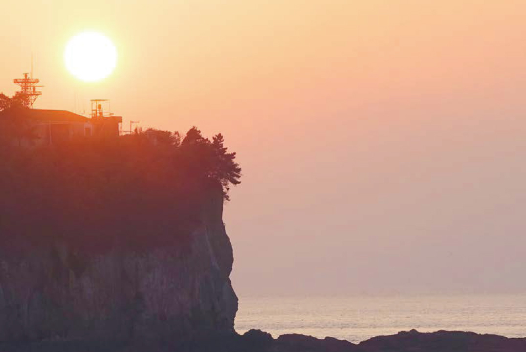
The sunset falls at the Gappo Beach. The time stops.
Behind the beautiful landscape, the 'Gappo Beach' begins to be seen.
If you're planning a full-day walk instead of one night, you'll see the sun sinking into the West Sea when you reach Gappo Beach.
The mystery of nature created by the sea
No one can easily talk in front of the majestic fall that may be the best in Korea.
At the end of the white sand beach of Gyeokpo Beach,
if you go up the hill and go through the Dakibong hill, you can reach the 'Gappo Port'. The journey ends at 'Haenom Park' at the end of Gappo Port.
-

Recommendation
The lodging facilities are
well-developed near Gyeokpo
beach and Gyeokpo harbor.
You can also enjoy the other
courses, sea bathing, fishing
and other leisures. -

Bus Terminal & Train Station
→ Start Point<Buan Bus Terminal>
Exit the right side
Buan Bus Terminal Stop
Seat Bus 100, Rural Bus 201, 211
> Get off at
'Seongcheon Village' Stop
10-minute walk (500m) toward
'Gosapo Beach' opposite -

Last Stop →
Bus Terminal & Train Station<Buan Bus Terminal>
5-minute walk (400m) toward
'Geokpo Port Passenger Terminal'
Take a seat Bus 100
at the Bus Stop
> Get off at Buan Terminal
3-minute walk across
the street (200m)
Arrive at Buan Bus Terminal -

Information Center & Representative
Banwol Information Center
010-3650-1310
Buan-gun Office Environmental Division
063-580-4442

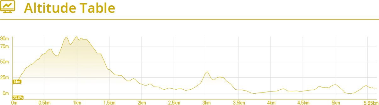
Haeneonyi Solseom-gil (Buan Masil-gil Course 4)
Dance of the sun coloring the sea red

When the sea goes down, the view is wide.
Sit back and relax.
The Haenumi Solnum-gil is a section that leads to the Jukbeok River Noeul-gil'. You can fully blend in the beautiful scenery to Solsum. If you climb the Haenumi Park' uphill, the vegetation unique to the warm seaside area, such as camellia, cypress, holly, and hawthorn, welcomes you on your journey.
The walk leads to the “Bongsudae” of the steep ridge. The open landscape would be the best location for observing enemies at sea. Lee Soonshin Settlement, which arrives next, is the place where Jeolla left swimming in the drama is set as the stage. Along with buildings such as Dongheon and Naea, the watchtower is well preserved and adds fun to see.
Solsum's fantastic fall
The Gunghang Village, which follows, is famous for fishing and cute villages. Busy fishing boats, fishing boats in the sea, and the walls of cute sculpture sculptures in every house are fun to visit.
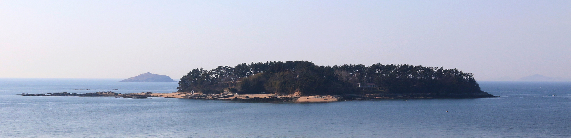
Soon you will see Solsum. It's a pity that the journey is coming to an end. Beyond Buan, he is soothing as he sees the solitude of Solsum, one of the best in Korea.
Head towards 'Surak Falls' behind the final 'Cheonbuk Student Training Center'. The magnificent sound of the water falls from over 100m and the magnificent sound of the rocky cliffs.
-
Recommendation
You can also walk in conjunction
the Jukbeok River Noeul-gil
(Buan Masil-gil 3-course).
Sol tide will
open at low tide. -
Bus Terminal & Train Station
→ Start Point<Buan Bus Terminal>
Exit the right side
Buan Bus Terminal Stop
Bus 100, Rural Bus 201, 211
> Get off at
'Geokpo Terminal' Stop
5-minute walk to
Haenumi Park (400m) -
Last Stop →
Bus Terminal & Train Station<Buan Bus Terminal>
Direction of Byeonsan
Police Training Center
20-minute walk from
Sangrok Stop (1.3 km)
Rural Bus 201, 211
> Get off at Buan Terminal
3-minute walk across
the street (200m)
Arrive at Buan Bus Terminal -
Information Center & Representative
Banwol Information Center
010-3650-1310
Buan-gun Office Environmental Division
063-580-4442

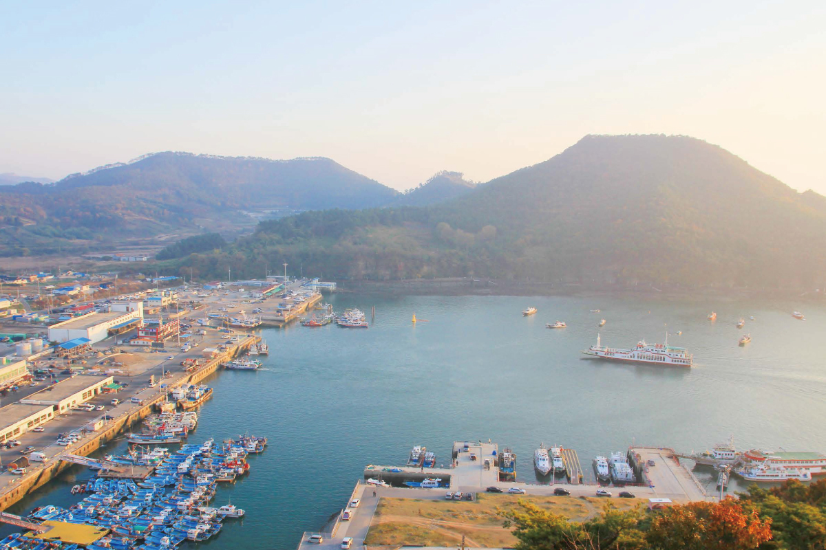
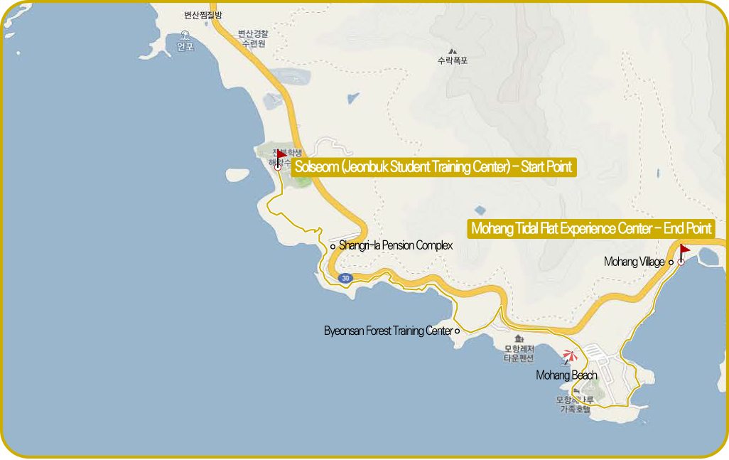
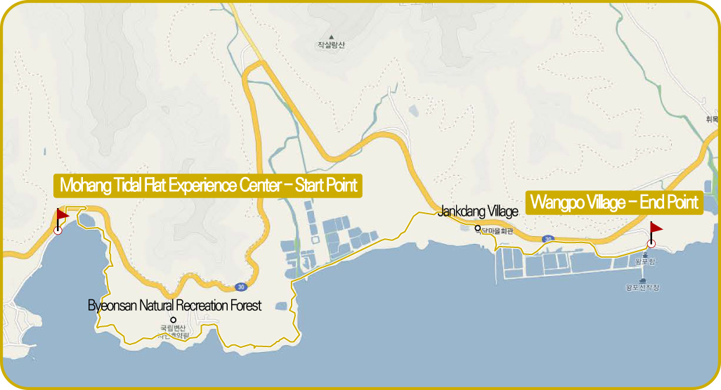
Mohang Tidal Flat Experience Road (Buan Drink Path 5 Courses)
Living tidal flats and the energy of life

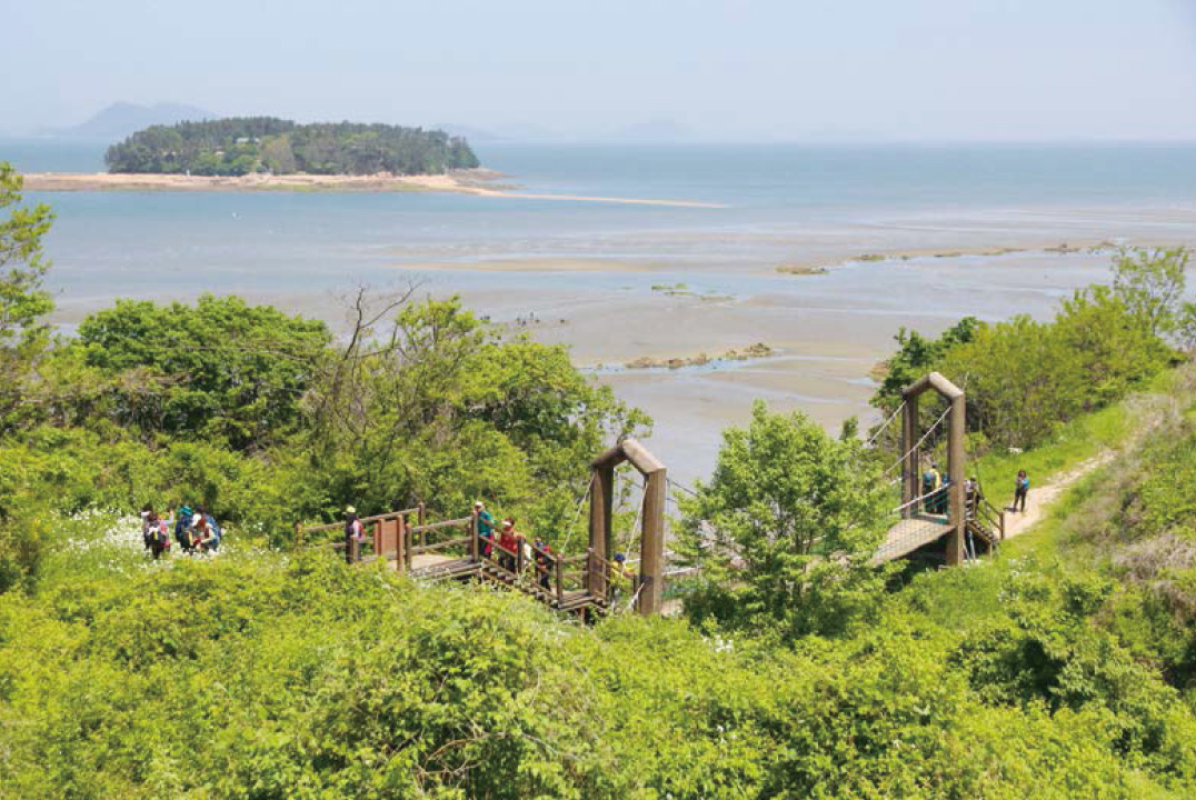
Walk south past Solsum, famous for its sunset.
It is a section leading to 'Hanumi Solsum -gil'. A 5km walk south of the West Sea, which borders the Byeonsan Peninsula, prepares to leave from Solseom (Jeonbuk Student Training Center).
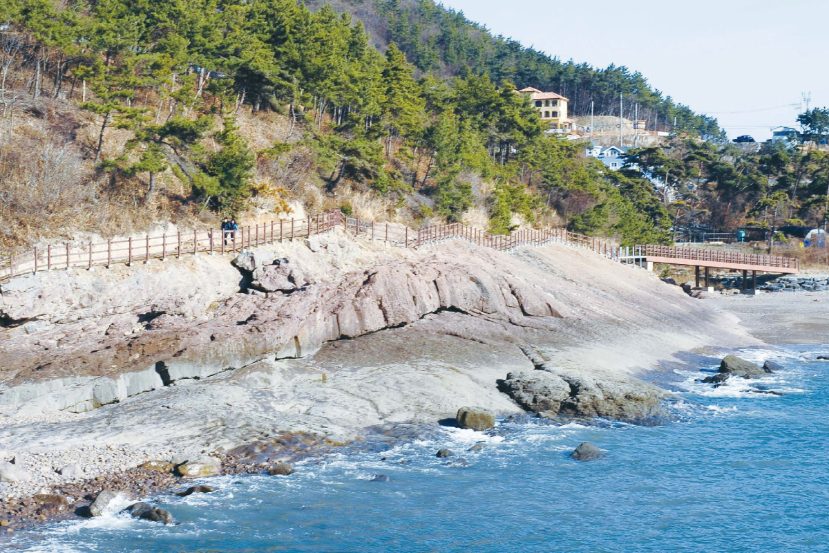
The main characters of the road, 'Solseom' and 'Mohang', have been designated as national geological parks because of their high scientific value and outstanding scenery. The exquisite combination of lava cliffs pushed down by the Mesozoic Cretaceous volcanic eruptions and alluvial rock overlaid with erosion made by weathering and algae is indescribably mysterious. Dark red purple sands are also very unusual. There is plenty of reason to come to the western end of Jeollabuk-do, enjoying the rare geological scenery.
Fresh sea breezes make you feel good
If you walk on the road, you will find both the solbat coast road and the path on the rock, which are romantic. In addition, mother port means that plants resembling reeds or pampas grasses grow in colonies. 'Fit Pool', facing the street, grows in a different area between the land and the land, forming a different landscape.
After that, the “Mohang Beach”, which touches the foot, appears far away at low tide, and the tidal-flat that reaches the horizon seems to relieve the frustrating feeling. The journey ends from 'Mohang Village' and 'Mohang Tidal Flat Experience Center'. When the sea fills up, people gather to experience various tidal-flat experiences such as digging shellfish.
-
Recommendation
You should visit Byeonsan Forest
training center. The various trails
and observatory decks are nice to
walk on. You can even stay the
night if you book in advance. -
Bus Terminal & Train Station
→ Start Point<Buan Bus Terminal>
Exit the right side
Buan Bus Terminal Stop
Rural Bus 201, 211
> Get off at
Sangrok Stop
20-minute walk to
'S-Oil Main Station' (1.3km) -
Last Stop →
Bus Terminal & Train Station<Buan Bus Terminal>
Direction of 'Mohang Village'
10-minute walk to
Mohang Station (700m)
Rural Bus 201, 211
> Get off at
Buan Terminal
3-minute walk across
the street (200m)
Arrive at Buan Bus Terminal -
Information Center & Representative
Banwol Information Center
010-3650-1310
Buan-gun Office Environmental Division
063-580-4442

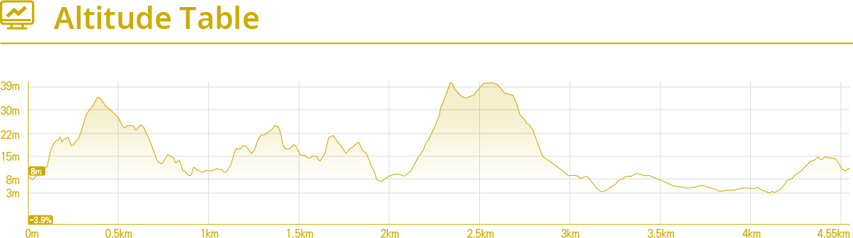
Ssanggyejae Nine Curves Road (Buan Masil-gil Course 6)
Beautiful Nature

Uphill and downhill
Leaving 'Mohang Tidal Flat Experience', the dirt road, lawn path, pine forest path and rock path intersect, and start the fun path that repeats the uphill and the downhill.
Leaving the experience hall, you can see the high hill, Ssangggyejae, which is just behind the Byeonsan Natural Recreation Forest. After a while, you will climb a rather steep path and you will see a small cape on the dazzling cliff. Tranquil silence and slow-moving fishing boats stop and look at all their anguish for a while.
After that, the walk goes through the sack forest. The scallop, which is overgrown, is also called 'Shinu-Dae'. The dense Shinu-Dae was not able to win the key, but was bent to create a tunnel, but when you step inside, you feel like you are the hero of an old story.
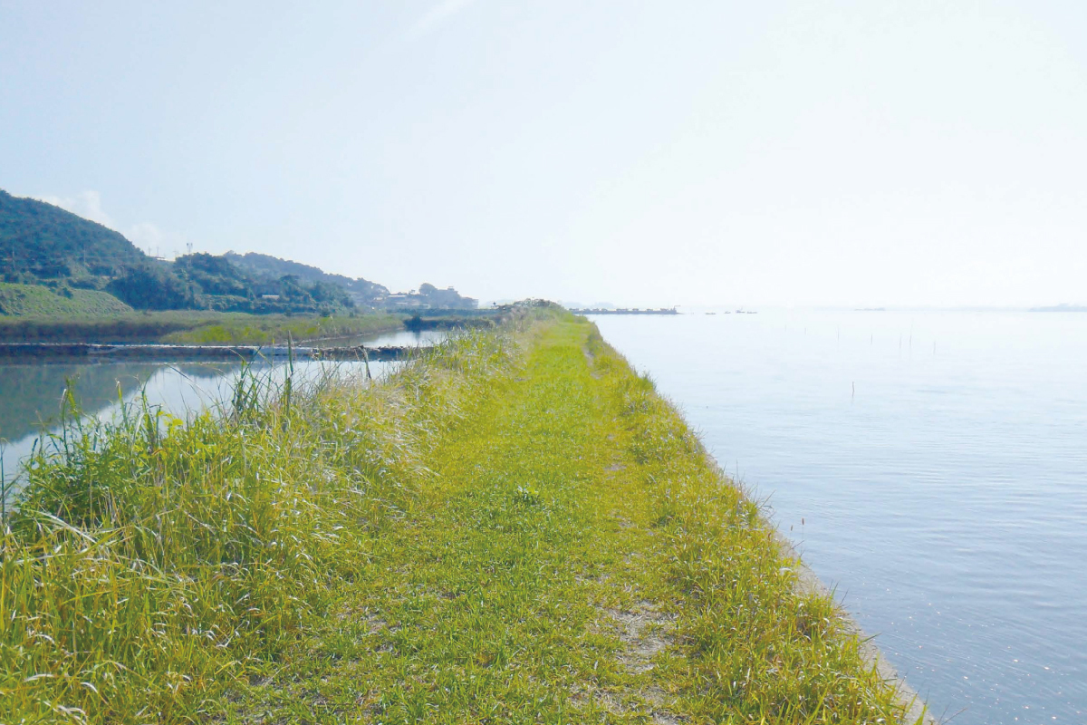
Tidal flats spread widely during ebb tide.
If you keep walking, you can see the tidal flats at Madong Seawall People, migratory birds, crustaceans and shellfish live in their own lives.
Passing through the long Soil Dam, you will reach 'Jankdang Village', famous for magpies and sunset, and 'Wangpo Village', the main hub of Chilsan fishery.
Under the blue sky, the scarlet one-colored roofs are further raised.
The journey ends at the sunny “Wangpo Village” pavilion, reminiscent of the Mediterranean beaches.
-
Recommendation
This place is famous for fishing.
There is the Gomso Harbor
nearby, so you can taste an
authentic Korean meal with
salted seafood. -
Bus Terminal & Train Station
→ Start Point<Buan Bus Terminal>
Exit the right side
Buan Bus Terminal Stop
Rural Bus 201, 211
> Get off at
Mohang Stop
10-minute walk
to Madong (700m) -
Last Stop →
Bus Terminal & Train Station<Buan Bus Terminal>
5-minute walk (320m) toward
Wangpo Village
Entrance Samgeori
Wangpo Stop
Rural Bus 201, 330, 350
> Get off at
Buan Terminal
3-minute walk across
the street (200m)
Arrive at Buan Bus Terminal -
Information Center & Representative
Banwol Information Center
010-3650-1310
Buan-gun Office Environmental Division
063-580-4442