
- Introduce
- Yongdam Dam Gamdong Byeorut-gil
- Unilam Banilam Forest Road
- Mai Mountain Road
The natural environment has been well-preserved, Jinan-gun
Jinan-gun has the second widest area after Wanju-gun, and most of its land consists of mountainous regions. The natural environment has been well-preserved, and it is known for the only highland plateau in Korea, the ‘Jinan Plateau’.
In AD 757, the 16th year of reign of King Gyeongdeok in Silla, the region’s name changed from Nanjina-hyeon (or Wollang-hyeon) to Jinan-hyeon, and since then, the name has been used. In the Goryeo era, it was called as Wollang-hyeon again, but it was called Jinan-gun since Joseon.
In Jinan-gun, the three river stems, Geum River, Seomjin River and Mangyeong River, met here.
Thus, Jinan-gun is a place of mountains and waters.
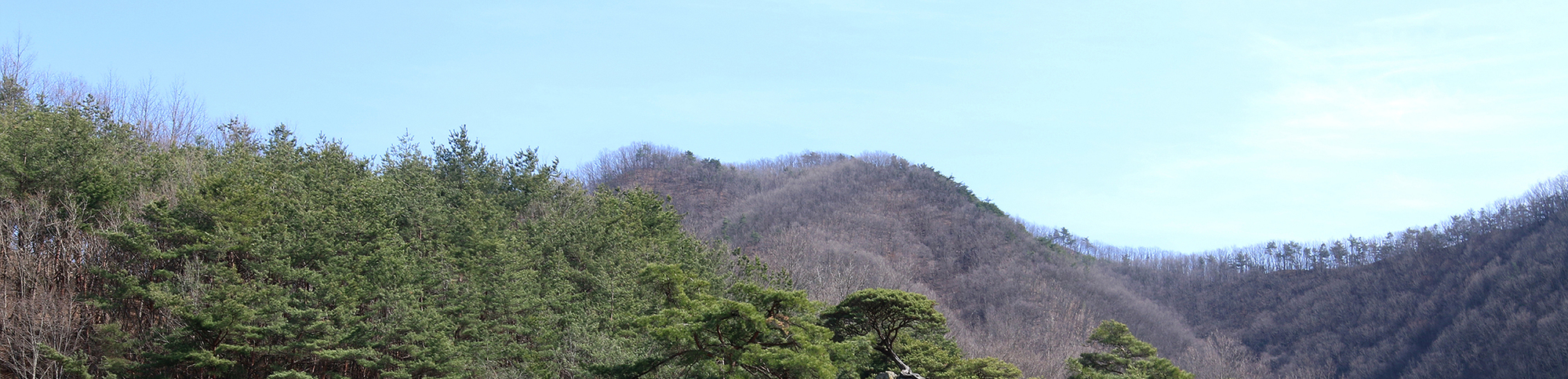
There many mountains famous for mountain climbing such as Unjang Mountain, Gubong Mountain and Mai Mountain.
The scenery aroung the Yongdam Lake is breathtaking indeed.
One cannot possibly miss out on Jinan Plateau located between the Sobaek mountain ridge and Noryeong mountain ridge.
In the East, there are the Daedeok Mountain, Deokyu Mountain, Baekun Mountain,
and they are all connected to Noryeong ridge that is about 1,200~1,300m above sea level.
The plateau located in between this place is 350~300m above sea level, and it is a significant place for geology
because the geological features from the ancient times can still be observed.
Jinan-gun has all the
incredible sceneries of Korea
The priceless trail in Jinan-gun in the Jinan-gun section of the Jeonbuk Cheolligil introduces places with great views and places that are not strenuous to walk.
Along the Yongdam Dam and the Yongdam Lake, you will see the Geum River, and you will also see the Seombawi in Yongdam Dam Gamdong Byeorut-gil. There is also the Unilam Banilam Trail where you can walk along the valley with incredible and bizarre stones. You will also be able to feel the miraculous features of Mai Mountain in the Mai Mountain Trail.
Jinan-gun has all the incredible sceneries of Korea. If you are a fan of hiking trips, you should try visiting Jinan-gun.

Yongdam Dam Gamdong Byeorut-gil
Lake meets the sky and Island rock


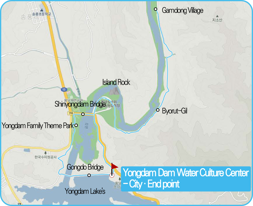

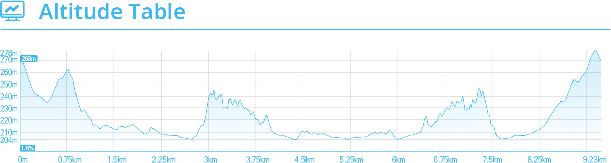
Thanks to the efforts of Jinan-gun, Jeollabuk-do has been supplied with water for living through Yongdam Lake. This is why we need to add gratitude to the views of Yongdam Dam and Yongdam Lake. 'Yongdam Dam Water Culture Center', a point of view of Yongdam Lake's moving street, is an exhibition hall and an education center built to convey the value of such a lake.
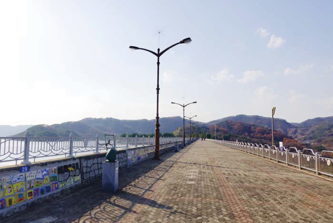
Panoramic view of Yongdam Dam
The Gongdo Bridge, which overlooks the top of the Yongdam Dam, can be accessed from 10 am to 5 pm. The wide lake overlooking Kongdo Bridge is very beautiful in addition to the open-air skyscape.
The forest that starts at the end of the bridge is connected to the Sinyoungdam Bridge' through the Yongdam Family Theme Park' filled with flowers.
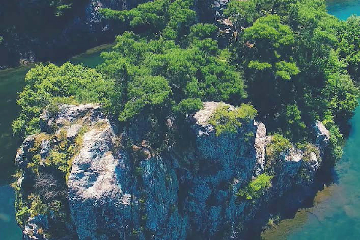
The magnificent view of the island rock.
and the shape of the pine trees are also wonderful.
If you walk for a while, the clear water of 'Island Rock' flows calmly and welcomes you on your journey. The island rock, which also became the background of the national anthem, boasted a beautiful ink painting.
It stands tall in the middle of the Geum River, but its shape is noble. The pine trees next to the rock also had unusual shapes. The landscape of Geum River, which blends with the sandy beaches of 10,000 pyeong, is attractive enough to stop.
Climb the flea road. The flimsy road that passes by the Geum River is quite thrilling.
I walked downstream and finally reached the footpath. A crayfish or a crayfish is Jinan's word for a cliff near a river.
Romantic to see the upper Kumgang to the left, as well as uphill and downhill, it offers a unique combination of thrills.
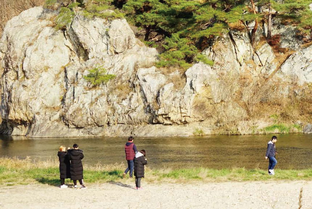
It is also rich in ferns and seems to look in the primeval primeval forest. If you pass the strange rock formations such as Muntukbow, 'Gamdong Village' will catch your eyes.
The village where the ferry was
The village was originally called persimmon village. The white sand beach in front of the village is where a ferry boat went, and it is a trail that crossed the river under a cliff. Perhaps the old ones crossed the Geum River by ferry. When you go nearby, there is an arrow to go back. The journey back to the scene is pleasant.
At the end of the journey, the electric village is full of peaceful and generous scenery. When going back, it is a formal course to go to Yongdam Dam Water Culture Center, which is just the end of the road from the Sinyongdam bridge, and it is enough to soothe the inconvenience of the road.
-

Recommendation
If the door to the Gongdo Bridge is
closed, check if entrance is
possible. It is worth walking there.
The road next to the cliff is nice to
walk in spring and late autumn. -

Bus Terminal & Train Station
→ Start Point<Jinan Intercity Bus Terminal
Public Stop>
Jinan Bus Terminal
Rural Bus bound for
Jinan-Songpung (Jeongcheon)
> Get off at Wangdugol Stop
Yongdam Dam
Palgakjeong Rest Area
25-minutes on foot (1.7km) -

Last Stop →
Bus Terminal & Train Station<Jinan Intercity Bus Terminal
Public Stop>
Yongdam Dam Sculpture Park,
16-minute walk
from Ancheon (1.1km)
'Jijang' Stop
Rural fishing bus bound for
Jinan (Songpung-Ancheon)
> Get off at Jinan Terminal -

Information Center & Representative
Jinan-gun Office Tourism Division
063-430-2511
Jinan Gowon-gil
063-433-5191

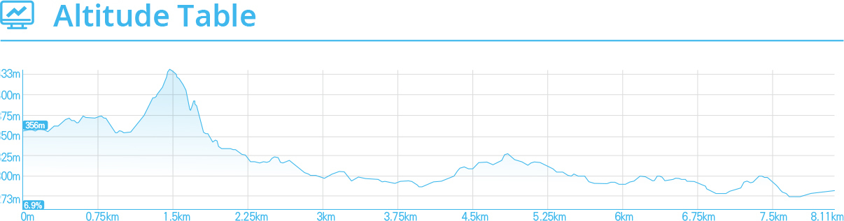
Unilam Banilam Forest Road
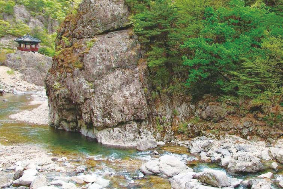
Mureungdowon, a strange rock formation where everything is superb

Huge and marvelous rocks
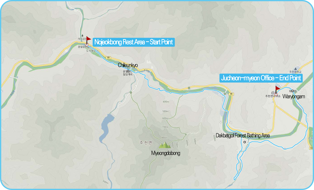
'Unil Ambanil-am Forest Trail', which is also the 9th section of Jinan Gowon-gil, begins in front of the 'Nojeokbong Rest Area'. The moment of meeting the huge and marvelous rocks with the cool sound of 'Joojacheon' is overwhelming enough to forget the way.
However, this road ends shortly in front of 'Chil Eun-kyo'. After that, you cross the road again into the forest, and if you take an uphill path along a fairly steep ridge, you will be greeted by a 'Uniljeong' built on a rock.
The highest point of today's journey, a mysterious landscape beneath the snow, seems to make up for the hard-working effort. The sweat waits for a tableware and hits a steep downhill. How narrow and severe the road would have been called the 'half-day cancer' which means 'the sun can only be seen in half a day'. You will have to move carefully.
Mysterious state of a flimsy road
Then, when you come down the road, you will meet the 'rainbow bridge' if you just climb up. Cliffs and waterfall deep water returning from the bridge is another admiration.
Passing through the 'auto camping ground', which has a large parking lot, the Myeongdo Bridge, the pine forest, and the Juyanggyo Bridge, it enters the 'Dakbatgol Forest Forest Bath. The valley is clean and the forest is alive. Continue to rush to take a short breath at Muk Hill and cross the bridge to see 'Waryongam'.
This mysterious state of nature continues until the end of the course.
Now it's a long way to the final office, Jucheon-myeon Office.
-
Recommendation
You can use the campsite at the
beginning of the course. 1 night
stay including the hiking and
the playing in the water is
recommended. It is such a
beautiful place to only walk
the trails once. -
Bus Terminal & Train Station
→ Start Point<Jinan Intercity Bus Terminal
Public Stop>
Jinan Bus Terminal
Rural Bus Jinan-Jucheon
> Get off at Samger Stop
Crossing the 'Nojuk Bridge to Nujuk Peak'
3-minute walk in direction (232m) -
Last Stop →
Bus Terminal & Train Station<Jinan Intercity Bus Terminal
Public Stop>
Jucheon Terminal Bus Stop
in front of
Boarding for Rural Fishing
Bus (Jucheon-Jinan)
> Get off at Jinan Terminal -
Information Center & Representative
Temporary Tourist Information Center
(open from July to August)
Jinan-gun Office Tourism Division
063-430-8711
Jinan Gowon-gil
063-433-5191

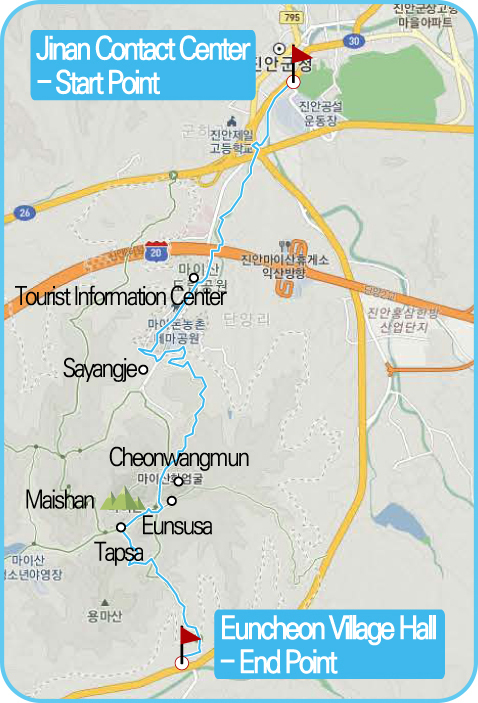
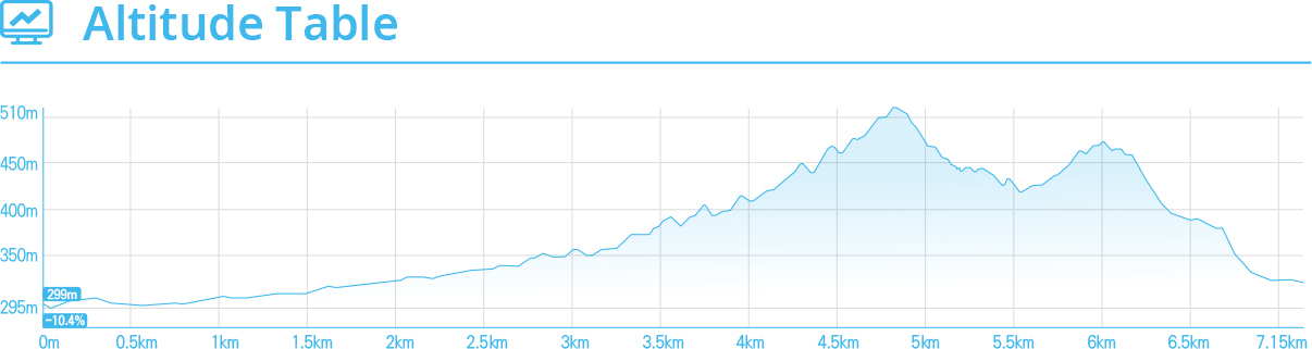
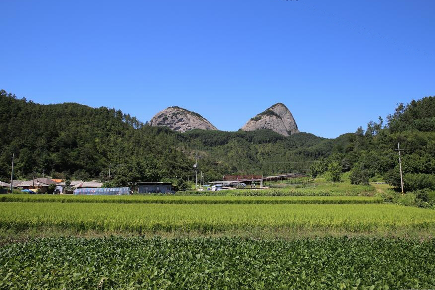
Mai Mountain Road
To check the phase of Maisan up close

Overwhelming Maishan Two Peaks
If you walk along the riverside at Jinan meeting place, you can see Maisan as far as the beginning of a path. That figure is worth three stars in the Michelin Guide. After a well-kept tourist information center, head to the 'Special Festival' where you can enjoy Maisan in a comfortable but close proximity. The two peaks of Mt. Mai on the bank are overwhelming.
The 'lover's road' that we will meet later has been changed to the electric car and people to the 'Cheonwangmun'. It takes more time, but you can climb the mountain slowly. 'Cheonwangmun' is the plateau between two peaks of Mt. After tasting the silver spring water, head toward ‘Eunsusa’. You can enjoy the natural monuments of the Blue Fruit Pear Tree and the Rope Tree.
Wherever you walk, Maisan looks at the walker.
Wherever you walk, Maisan looks at the walker. Facing 'Eunsasa' and facing 'Topsa',
the mysterious and enormous stone pagoda is enduring a long time with its greatness.
There are only a number of stories about who made what and when.
It's easy to get lost if you leave 'Topsa', so you can quickly turn to the left and follow 'Jungan Gowon-gil's milestone to enter 'Dojanggol'.
If you walk a long time, you can see Maisan.
If you go downhill afterwards, it is the end of Euncheon Village. In order to prevent frequent fires in the village, the village forest and stone turtles have been restored,
and the journey ends at the Euncheon Village Hall
-
Recommendation
There are various mountain
hiking courses such as the Female
Maibong and Bongdubong, so you
can also enjoy mountain climbing. -
Bus Terminal & Train Station
→ Start Point<Jinan Intercity Bus Terminal
Public Stop>
Jinan Intercity Bus Public Stop
11 minutes on foot from
Jinan Post Office (731m) -
Last Stop →
Bus Terminal & Train Station<Jinan Intercity Bus Terminal
Public Stop>
Euncheon Intersection Stop
Boarding for
Rural Bus (Myeong-Jin)
> Get off at Jinan Terminal -
Information Center & Representative
Jinan-gun Office Tourism Division
063-430-8711
Jinan Gowon-gil
063-433-5191